Stay informed with free updates
Simply sign up to the Climate change myFT Digest — delivered directly to your inbox.
The top US climate agency is rethinking its modelling of the critical Pacific Ocean cycles that feed into the world’s atmospheric shifts, as record hot sea temperatures globally scramble weather patterns.
Scientists at the US National Oceanic and Atmospheric Administration (Noaa) told the Financial Times they were holding discussions internally and consulting other national agencies about how to make forecasts more accurate.
“It’s certainly an indication that global warming is messing with the traditional ways we monitor events,” said Nathaniel Johnson, a scientist on a team that develops the US models. “We should consider . . . whether our traditional metrics will still work as well given how much our oceans are warming.”
This follows a recent move by Australia’s Bureau of Meteorology to stop publishing a key short-term forecast after a backlash from farmers earlier this year, when predicted dry conditions turned into flooding.
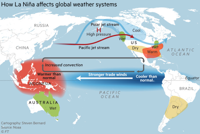
Changes to the temperature of one area of the tropical Pacific Ocean have until now underpinned observations of the naturally-occurring so-called El Niño warming effect or La Niña cooling effect by major weather and climate agencies.
Swings in the temperature of this defined zone shape extreme weather events and temperatures over a years-long cycle, with effects felt right across the globe, bringing heavy rain to some regions and parching others as a consequence.
These pendulum swings from hot to cool take place every few years, and farmers, commodity traders and disaster agencies rely on the phenomenon being accurately modelled to prepare for the impact.
But some scientists say that, as climate change may be interfering with the way the cycles are measured and the effects they create, the warming of tropical oceans around the world may need to start being factored in. “It is being discussed,” said Michelle L’Heureux, who leads the team that develops the Noaa modelling of the El Niño and La Niña effects.
The phenomenon has until now been monitored using a technique broadly unchanged since the 1990s. British climatologist Gilbert Walker was one of the first to notice in the 1920s that a “see-saw” in atmospheric pressure in the Pacific seemed to predict global weather patterns with some certainty.
Last year, El Niño helped drive global temperatures to a new record, accentuating the warming effects from rising greenhouse gas concentrations in the atmosphere. It also triggered a drought in Central America, which caused historic low water levels in the Panama Canal and immobilised shipping.
This year, scientists anticipate weather patterns could be out of sync with the anticipated La Niña phenomenon that would be expected to bring the usual effects, such as drier weather over the southern US, either later or less intensely.
“It’s concerning when this region we’ve studied and written all these papers on is not related to all the impacts you’d see with [La Niña],” L’Heureux said. “That’s when you start going ‘uh-oh’ there may be an issue here we need to resolve.”
Forecasters have been unnerved by the erratic timing. In June, the US agency said with 85 per cent certainty that La Niña would be declared between November and January 2025. The cooling effect could have acted as a temporary brake on the rate of global temperature rise.
However, its latest forecast concluded that the cooling was now most likely between March and May, and that it would be “weak and shortlived”.
The EU earth observation agency Copernicus also said that more sophisticated prediction tools for the variety of influences over rain and temperature globally meant that “inferences” based on historical trends such as the Pacific phenomenon had less value than in the past.

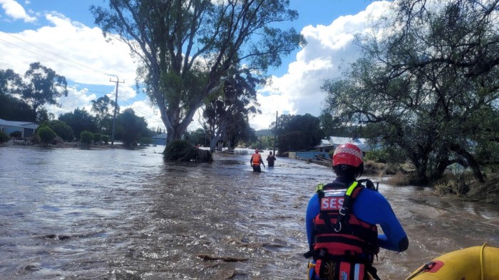
A rare so-called “triple” La Niña event was experienced from 2020 to 2023, before the more short-lived El Niño. Beleaguered Australian farmers complained this year about sustaining losses after selling their livestock when the national weather bureau declared an onoing El Niño event in September 2023, forecasting its effects would last the southern summer into early 2024. This would have typically increased the chances of drought but instead there were torrential rains in some areas.
The Australian bureau hosted an online discussion about the difficulties of modelling El Niño in an era of global warming, with participating scientists from New Zealand, South Korea, Japan, New Caledonia, Singapore and the US. It is advanced in adopting a new “relative” index that takes global tropical ocean temperatures into account, according to a meeting summary.
“As our climate continues to change, our historical experience is less aligned to the present and future climate,” the agency told the FT in a statement.
Climate Capital

Where climate change meets business, markets and politics. Explore the FT’s coverage here.
Are you curious about the FT’s environmental sustainability commitments? Find out more about our science-based targets here
Source link


